Flooding Updates on the Nisga'a Highway

Flooding Updates on the Nisga'a Highway
June 5, 2021 - 10:20am
The water level has dropped significantly overnight, and there is down to about 30cm or so in the deep parts.
We are opening the road shortly to two way traffic for vehicles with high clearance. There is some damage to the shoulders, so it is a bit narrow in places through there. Emil Anderson is going to put out some delineators to mark it, and drivers should use caution through there.
We expect to be able to open to all traffic by early this afternoon. Emil Anderson, and Ministry staff will be assessing the roads and bridges throughout the day today.
The No Name wall area has minimal water on the road, but there is damage to the shoulder and asphalt in that area as well.
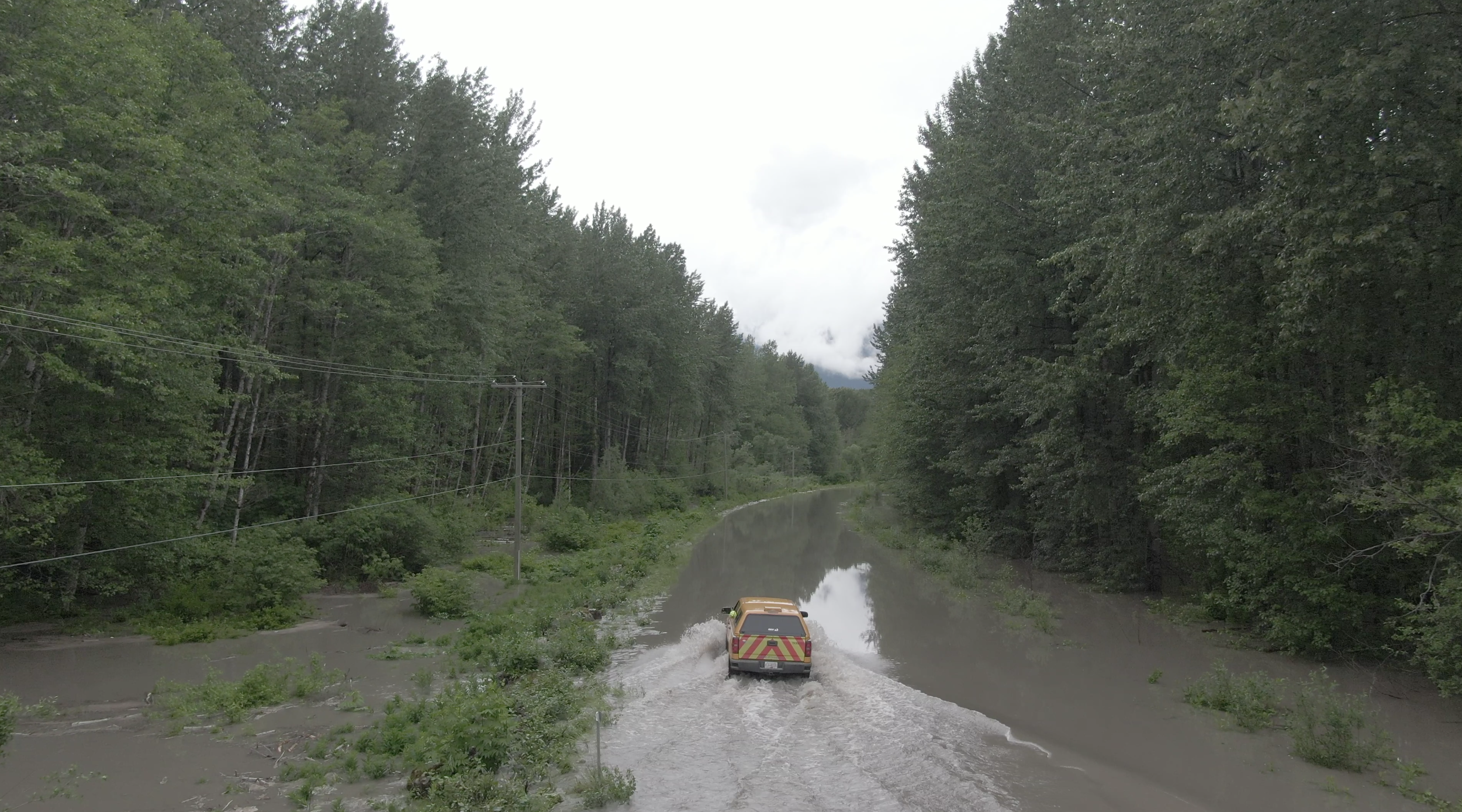
June 4, 2021 - 6:13pm:
The Ministry of Transportation and Infrastructure has confirmedthat Nisg̱a’a Highway 113 will be closed overnight because the water level has not subsided enough to allow for safe passage of vehicles. Water levels continue to lower in most sections along the lava beds so we are hopeful conditions will improve overnight and most if not all routes will be able to be opened in the morning.
The contractor will assess in the morning and we will update Drive BC the conditions are known.
June 4, 2021 - 12:39pm
The waters rose more overnight but appears to be cresting. The full highway closure remains in effect and the next update from the Ministry of Transportation and Infrastructure will be at 4:00pm.
Please check www.drivebc.ca for current updates. Continue to stay safe!
June 3, 2021 - 5:35pm
High Flood Warning – Ministry of Transportation and Infrastructure has closed the Nisga’a Highway from Y (on lava beds) to Laxgalts’ap due to increased water levels at WD Mckay Bridge. Highway Crews will re-evaluate the highway at 8:00 am Friday June 4, 2021.
DriveBC website is currently down and does not have updated information. Please remain home until further notice, contact your Village Government for any assistance.
June 3, 2021 - 12:25pm
HIGH FLOOD WARNING - Ministry of Transportation and Infrastructure has closed the Nisga’a Highway to light duty traffic (Cars and Small SUV’s) at Mckay Bridge.
Travel in small cars and SUVs is not recommended in the Vetter Creek area on lava beds (A-frame to Tree Mould) and between the Nass Road and Big Cedar Bridge (45.2 km marker) due to flooding over the road. Recommend only trucks at this time. More information to come as soon as available.
June 3, 2021 - 11:14am
Between Gitwinksihlkw and Gitlaxt’aamiks on the lava beds:
HIGH FLOOD WARNING - Ministry of Transportation and Infrastructure has closed the Nisga’a Highway to light duty traffic (Cars and Small SUV’s) at Mckay Bridge, Vetter creek area on lava beds (A-frame to Tree Mould) and between nass road and Big Cedar Bridge (45.2 km marker) due to flooding over the road. Recommend only trucks at this time. More information to come as soon as available.
June 3, 2021 - 8:07am
The Ministry of Transportation and Infrastructure has closed the Nisga’a Highway at the McKay Bridge to light duty traffic (small cars) due to flooding over the road.
Please check www.drivebc.ca for further updates.
Travel safe!